iMMAP Successfully Delivers Risk Mitigation Resource Center (RMRC) Project in Iraq

The Risk Mitigation Resource Center (RMRC) project in Iraq is now closed after over a year of implementation. During its existence, the project successfully collected data on incidents to inform humanitarian actors and partners so they can conduct their operations safely.


Figure 1. Screenshot of the Risk Mitigation Resource Center's dashboard (07/01-11/30/2022)

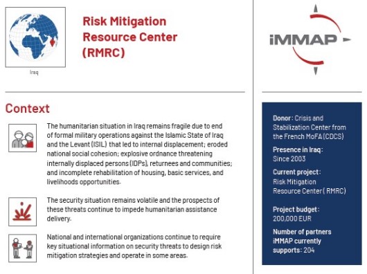
The RMRC project was created to inform humanitarian actors and other partners on the security situation in Iraq. Despite the end of formal military operations against the Islamic State of Iraq and the Levant (ISIL) the situation remains problematic, making humanitarian help precarious.  This is due to incomplete rehabilitation of housing, essential services, livelihood opportunities, internal displacement, and weakened national social cohesion. Furthermore, Unexploded Ordnance (UXO) and other explosives pose a serious threat to displaced people and returning families as they attempt to rebuild their lives. 

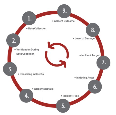
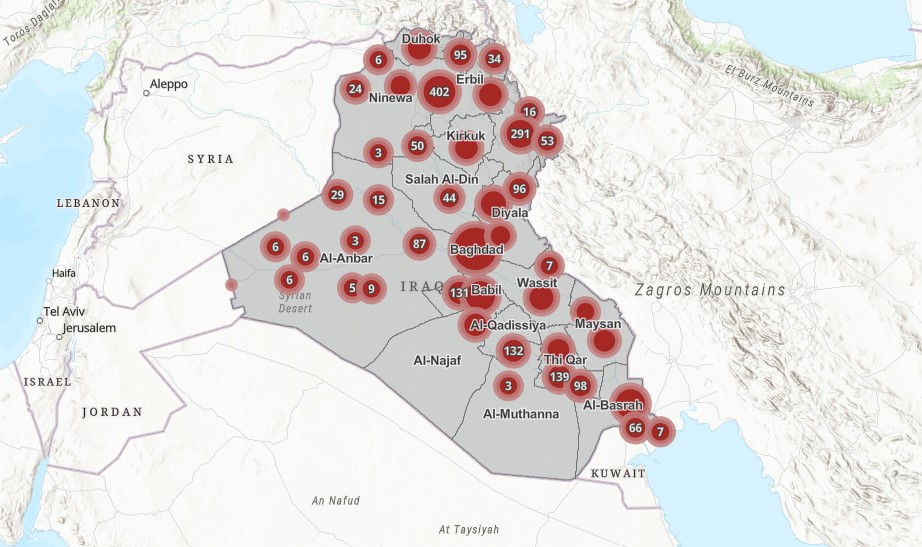
The goal of this project was to help partners better understand the country's current situation. This was done by sharing information about accidents, crimes, explosive hazard occurrences, national security operations, natural disasters, and public demonstrations. The information was then made available through monthly interactive products that included the number and types of incidents, patterns over time and location, trends in types of casualties like targets and initiating actors, as well as casualties. The incidents data were collected from reputable news sources, and their accuracy was checked by comparing data from at least three separate reports. When information reliability was threatened by unreliable sources or misreporting, contextual analysis helped boost verification processes. 


Figure 2. Incident Reporting System: Standard Working Procedure

Check our snapshot of the Risk Mitigation Resource Center project in Iraq


iMMAP Iraq has also designed and developed a Geoportal free-to-access and dynamic platform for sharing data and information about different incidents in Iraq. It was built on a custom Geographic Information System (GIS) which provides geolocation capabilities for incidents that occurred. By using that system, partners were able to obtain detailed information on incidents such as location, and the number of casualties according to different categories identified with their sources. The geoportal allowed users to have direct access to high-level summary information with a single click on the map or filter search (e.g., by incident type or province) to see detailed information on specific incidents or incidents related to certain actors. The dynamic map enabled access to each incident record's details and source of data. The dashboard was specifically tailored to seven governorates in Iraq (Anbar, Baghdad, Diyala, Erbil, Kirkuk, Ninewa, and Salah Al-Din).